
Drone Stock Footage in 2026: How to Shoot, Keyword, and Sell Aerial Video That Actually Downloads
Key Takeaways
Drone footage earns significantly more per clip than ground-level video — average $3.38/clip/year for a well-managed portfolio, with individual clips earning $20–$150+ on extended licenses
The "famous landmark" strategy is a dead end for new drone contributors — geographic specificity and underserved locations consistently outperform iconic destinations in download rates
Timelapse, hyperlapse, and dronelapses are the highest per-clip earners in drone footage — buyers pay premium prices for technically complex motion sequences that are difficult to replicate
Drone metadata is critically underoptimized by most contributors: aerial footage has a distinct commercial vocabulary (establishing shot, bird's eye view, reveal shot, fly-through) that visual recognition tools don't generate
Legal compliance documentation — FAA Part 107, EASA certification, location permits — is increasingly verified by premium platforms and its absence is grounds for footage removal
Why Drone Footage Is One of the Best Stock Video Niches Available
I've tracked contributor earnings data from drone-focused microstock operators for two years, and the consistent pattern is this: a drone contributor with a 200–500 clip portfolio, shot across 8–12 geographically diverse locations, built with proper timelapse and hyperlapse coverage, consistently earns $300–$800/month. That's from a portfolio that represents 15–25 shooting days of work and requires minimal ongoing effort once built.
The reason drone footage commands premium economics is the production barrier. A buyer who needs aerial footage of a coastal city or a mountain landscape cannot produce it themselves. They can hire a drone crew locally for $500–$2,000 per day, or they can license stock footage for $15–$75 per clip. Most projects choose the license, which means the demand is both broad and economically motivated. This is the structural condition that makes any stock content category valuable: buyers who need specific content and have a clear alternative that costs more.
The drone footage market in 2026 is also in an interesting transitional state. DJI's dominance of the prosumer drone market means that footage quality is increasingly uniform — the production floor has risen significantly. This creates an opportunity for contributors who invest in distinctive locations, sophisticated shot types (orbit reveals, tracking shots, complex hypers), and excellent metadata rather than just high-resolution footage of popular destinations.
"The best drone footage money doesn't come from the shots everyone else is flying. It comes from the angles no one else has bothered to reach."
The Four Shot Types That Sell: A Buyer's Perspective
1. The Establishing Reveal
The most commercially versatile drone shot: starting with a close, partially obscured view of a location and pulling back or ascending to reveal the full context. Used in documentaries, corporate videos, advertising, and real estate marketing. The keyword vocabulary for this shot type is distinctive: establishing shot, aerial reveal, bird's eye reveal, drone pull-back, overhead reveal, panoramic reveal. These are buyer-intent keywords — they're what an editor types into a search bar when they need this specific shot, not just "aerial view" or "drone footage."
2. Timelapse and Hyperlapse
Timelapses condense extended time periods (sunrise to sunset, city rush hour, construction progress) into short clips of 10–30 seconds. Hypers move the drone through space while compressing time, creating flowing motion that is visually distinctive and technically impressive. Both formats command significantly higher prices than real-time footage on Pond5 (where contributor price control applies) and generate higher download rates on flat-fee platforms because they're functionally irreplaceable — a buyer cannot simply slow down real-time footage to achieve the same effect.
Pricing guidance for Pond5 specifically: standard real-time 4K footage in a competitive location should be priced at $35–$49. Timelapse of the same location at $69–$89. Hyperlapse at $79–$99. Unique or hard-to-reach location content at the top of each range. Start lower and raise by $10 after each sale, as Pond5 community wisdom consistently recommends.
3. Tracking and Follow Shots
Following a moving subject from above — a vehicle on a mountain road, a person walking through an urban environment, a boat crossing a harbor — creates footage with built-in narrative motion that's immediately useful for advertising and documentary applications. These shots require more technical skill than static hovering shots and are therefore less common in stock libraries, which gives them a natural scarcity premium.
4. Geometric and Abstract Aerial Patterns
Agriculture, industrial facilities, highway interchanges, solar farms, and urban grid patterns from directly above create abstract geometric compositions that buyers use as concept imagery, background footage, and visual metaphors for technology, scale, and systems. These shots require no model releases (no people), no property releases in most jurisdictions (industrial facilities visible from public airspace), and no expensive locations — a well-composed shot of agricultural irrigation patterns or a highway interchange can generate downloads for years.
Geographic Strategy: Where to Fly for Maximum Commercial Return
The strategic framework for geographic coverage is: start with where you are, go deep before you go broad, and prioritize underserved locations over iconic ones.
Your immediate geography first. The location you know best — your city, your region, your regular routes — contains footage that you can shoot repeatedly, in different seasons and lighting conditions, without travel cost. A contributor who builds comprehensive coverage of a single city (15–20 distinct locations, multiple shot types per location, different seasons represented) has a defensible and continuously saleable portfolio even if that city isn't internationally famous.
Underserved mid-tier cities. Cities with populations between 100,000 and 1,000,000 are consistently undersupplied in drone stock footage relative to buyer demand. Regional advertising agencies, local news organizations, real estate companies, and development firms based in these cities actively search for aerial footage of their specific location and find limited options. The competition per search query in these locations is a fraction of what it is for major metros.
Industrial and agricultural content. Factory facilities, distribution centers, mining operations, farmland at scale, and energy infrastructure (wind farms, solar installations, refineries) generate consistent demand from B2B buyers in industry reports, corporate communications, and technical media. This content is rarely shot by consumer drone operators and is therefore chronically undersupplied.
Natural environments off the beaten path. Secondary mountain ranges, regional forests, estuaries and wetlands, and desert landscapes outside the famous national parks category all have active buyer demand and low supply. The footage doesn't need to be of somewhere famous — it needs to be visually distinctive and technically excellent.
Drone Footage Metadata: The Keywords Nobody Writes
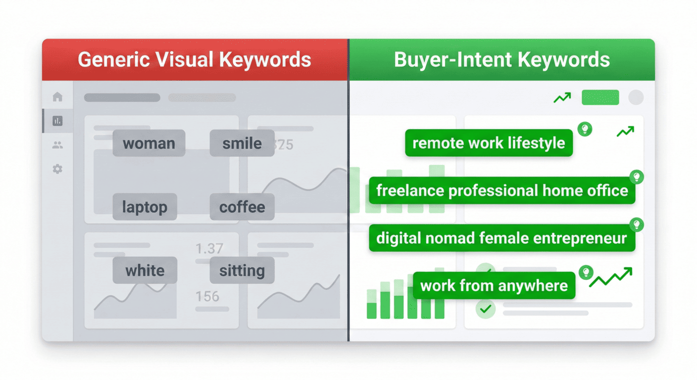
Here is the specific metadata failure I see repeatedly in drone footage submissions. Contributors write keywords that describe what the footage shows — city, aerial, buildings, traffic, urban, drone, 4k, night — and miss the entire commercial vocabulary that buyers search when they need aerial footage.
Buyers searching for aerial footage use shot-type terminology, not location or subject terminology alone. The keywords that drive drone footage downloads:
Shot type: establishing shot, aerial reveal, bird's eye view, overhead view, fly-through, tracking shot, ascending shot, descending shot, orbital shot, rotating aerial
Motion type: timelapse, hyperlapse, dolly in, pull-back, pan, hover, forward motion, lateral movement
Altitude and angle: low altitude, high altitude, directly overhead, 45-degree angle, rooftop level, treetop level
Lighting and time: golden hour aerial, blue hour city, midday aerial, dawn light, dusk cityscape
Commercial use cues: city overview, infrastructure aerial, real estate aerial, event coverage aerial, nature documentary, corporate aerial
Most visual AI keywording tools do not generate these terms because they don't exist in the visual content of the image — they describe how the footage was captured and how it's commercially used. This is precisely the buyer-intent vocabulary gap that CyberStock's market-data training addresses.
Legal Compliance: The Detail That Ends Accounts
Adobe Stock's contributor terms require that you certify all footage was shot legally, with appropriate licenses and permits where required. Pond5 has similar requirements. This is not a formality — platforms are increasingly auditing high-volume contributors for legal compliance documentation, particularly in the wake of several high-profile cases where drone footage submitted to stock agencies was found to have been shot in restricted airspace or without required certification.
In the United States: FAA Part 107 Remote Pilot Certificate is required for any commercial drone operation. Flying above 400 feet AGL without authorization, in controlled airspace without LAANC approval, over crowds or moving vehicles, or at night without a waiver can result in significant FAA penalties — and submitting footage from non-compliant flights to stock agencies can result in account termination if the legal status is questioned.
The practical advice: keep your Part 107 certificate current (renewal every 24 months), log every flight with location, time, and LAANC authorization number, and document any special permits for restricted locations. This documentation takes 5 minutes per flight and protects an income stream that can take years to build.
Building a Drone Stock Portfolio: 90-Day Roadmap
Days 1–30: Establish local coverage. Identify 5–8 shootable locations within your regular operating area. Shoot each location at different times of day (golden hour, blue hour, midday) with the four core shot types: establishing reveal, overhead static, timelapse, and tracking/lateral movement. Submit to Adobe Stock and Pond5 with properly structured metadata.
Days 31–60: Add technical shot types. Add hyperlapse coverage to your best locations. Hyperlapse requires ND filters, careful planning, and post-processing — it's worth the investment because hyperlapse clips earn 30–50% more per download than real-time footage. Submit these as a separate catalog expansion.
Days 61–90: Expand geographic coverage. Identify 2–3 locations that represent underserved geographic categories: a mid-tier city you can access, an industrial facility, a distinctive natural environment outside the crowded national park categories. One well-executed location expansion can add 20–40 clips to your portfolio.
At 90 days with consistent execution, a drone contributor following this roadmap should have 100–200 clips approved across Adobe Stock and Pond5, with early download data to guide continued portfolio development.
Keyword your drone footage with buyer-intent terminology automatically: cyberstock.lol